Virginia GeoInquiries are modeled after Esri’s GeoInquiry collections. A GeoInquiry is a scripted learning activity based on a map with multiple layers, tools, and symbols.
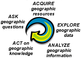
The process of geographic inquiry includes 5 stages: Ask, Acquire, Explore, Analyze, and Act is These stages are included in the questions posed in the geoinquiry. Read more about process of geographic analysis here.
Designed for whole class use, each geoinquiry is estimated to be completed in 15 – 30 minutes. The activities employ the Geographic Information System available in ArcGIS Online and require no log-in.
Virginia GeoInquiry list
- GeoInquiry 1: Jamestown 1607-1634
- GeoInquiry 2: Where do Virginia’s People Live?
- GeoInquiry 3: Virginia in the American Revolution
- GeoInquiry 4: Agriculture in Virginia
- GeoInquiry 5: Standing Up to Jim Crow
- GeoInquiry 6: Land Use in the Chesapeake Bay
- GeoInquiry 7: in development
- GeoInquiry 8: Coal in Virginia’s Economy
Designed by Chris Bunin, Albemarle High School; Georgeanne Hribar, Old Dominion University; and Christina Troxell, Old Donation School explore key topics in Virginia Studies. These Virginia-based GeoInquiries are aligned with the Virginia Standards of Learning for Virginia Studies and Science. The GeoInquiries are available to the public at no cost and were made possible with support from the Virginia Geographic Alliance and Esri.
Geographic Information Systems

A Geographic Information System employs computer technology to link locations with data. Underlying each map is a table of data linked to a specific theme or topic such as population. Symbols on the map convey relative locations and quantities that reveal patterns and relationships. Multiple layers offer opportunities to investigate relationships between and among the data.
ArcGIS Online, the platform for the GeoInquiries, showcase the maps, their data, and used Map Notes and Pop-ups to provide access to additional information. For best results use the Chrome browser to explore ArcGIS Online.
The ArcGIS Online mapping platform is freely available to U.S. public, private, and home schools as part of the White House ConnectED initiative. A school subscription provides additional security, privacy, and content features. Learn more about ArcGIS Online and how to get a school subscription at http://connected.esri.com
Access the Virginia GeoInquiries
Use the menu at the top center of this page to access the web page for each of the Virginia GeoInquiries. Each page contains an overview of the topic, the Geo Inquiry pdf (with answers), link to student worksheet (without answers), and link to the map itself. The Virginia GeoInquiries can also be accessed from the Virginia Geographic Alliance’s Organizational Account at https://vga.maps.arcgis.com. For best results use the Chrome browser.