Scenario
The City of Virginia Beach has undertaken an extensive process to evaluate and prioritize policy and planning responses as part of the city’s comprehensive response to flooding.
 Imagine you are a key decision maker for the City of Virginia Beach who has been asked to consider several of these policy and planning options. As such, you will need to learn about the Comprehensive Flooding Response Plan (CFRP) process and resulting policies and solutions.
You are also a resident of the Virginia Beach and are concerned about the challenges facing the city regarding resilience, emergency response, cost, and livelihood.
Before you make any decisions, you decide to gather as much information about potential response plans as possible.
Task
Read through each of the six stations below.
 Respond with your preferences and beliefs by completing the survey at the end of every station.
Important Note
 For the Participant ID question at the beginning of each survey, input the first letter of your first name followed by the last four (4) digits of your phone number (the Participant ID should look something like this S6735 or B3027). This is to make sure your responses stay anonymous, but also so that researchers can connect your responses across each of the six surveys.
Reading and responding to each of the six stations takes approximately 45-60 minutes total.
 Your responses will be collected by researchers at Old Dominion University and will be shared with the City of Virginia Beach with the goal of informing their policy decisions.
Station 1: Overview
In order to address existing short- and long-term flood risks, Virginia Beach has undertaken a thorough, City-wide analysis to develop strategies and solutions that promote resilience.
![]() First things first: We need to know a little bit about you, and also want to briefly inform you on the general approach to flooding currently taken by the City of Virginia Beach, which has just undertaken a thorough analysis to develop strategies and solutions that promote resilience across the city.
First things first: We need to know a little bit about you, and also want to briefly inform you on the general approach to flooding currently taken by the City of Virginia Beach, which has just undertaken a thorough analysis to develop strategies and solutions that promote resilience across the city.
The City of Virginia Beach is developing plans to address both repetitive flooding and projected increases in flooding through two main studies.
Comprehensive Sea Level Rise and Recurrent Flooding (CSLRRF) Study
(1) Assessing existing and future flood vulnerabilities across the City's four unique watersheds.
(2) Identifying strategies to ensure our city is resilient to future flooding events.
Master Drainage Study
(1) Detailed inventory of the City's stormwater system.
(2) Assessing system performance.
(3) Identifying deficiencies or need improvements.


 In order to address existing and future flood risks, the City is considering a wide range of possible strategies: structural, nonstructural, and natural and nature-based interventions to decrease short- and long-term risk. Proposed strategies are being evaluated through a multi-factor feasibility rating for prioritization to identify the most effective and practical solution set.
Station 2: Policy-Based Solutions
Policy-Based solutions consist of zoning laws, ordinances, codes, regulations, tax incentives, and financial mechanisms that can enhance the City's resilience to flooding.
![]() Having just been informed about the city’s analysis, let’s now transition into the various policy-based decisions that will need to be made. These policy-based solutions consist of zoning laws, ordinances, codes, regulations, tax incentives, and financial mechanisms that can enhance the city’s resilience to flooding but also come at some cost. We would like to know where your preferences stand.
Having just been informed about the city’s analysis, let’s now transition into the various policy-based decisions that will need to be made. These policy-based solutions consist of zoning laws, ordinances, codes, regulations, tax incentives, and financial mechanisms that can enhance the city’s resilience to flooding but also come at some cost. We would like to know where your preferences stand.
What is a Policy Report?
(1) Guidelines for instilling policy based adaptation solutions to reduce long term flood risk.
(2) Starting place from which flood vulnerabilities can be addressed from a policy perspective.
(3) Presentation of activities that the City should explore, evaluate and/or undertake as part of a comprehensive long term approach.
(4) Reflection of City-wide staff perspective and priorities.
Why is a Policy Report important?
Policy solutions can be implemented faster and at a significantly lower cost than large built interventions. Policy changes are just one set of tools in the resilience toolbox.


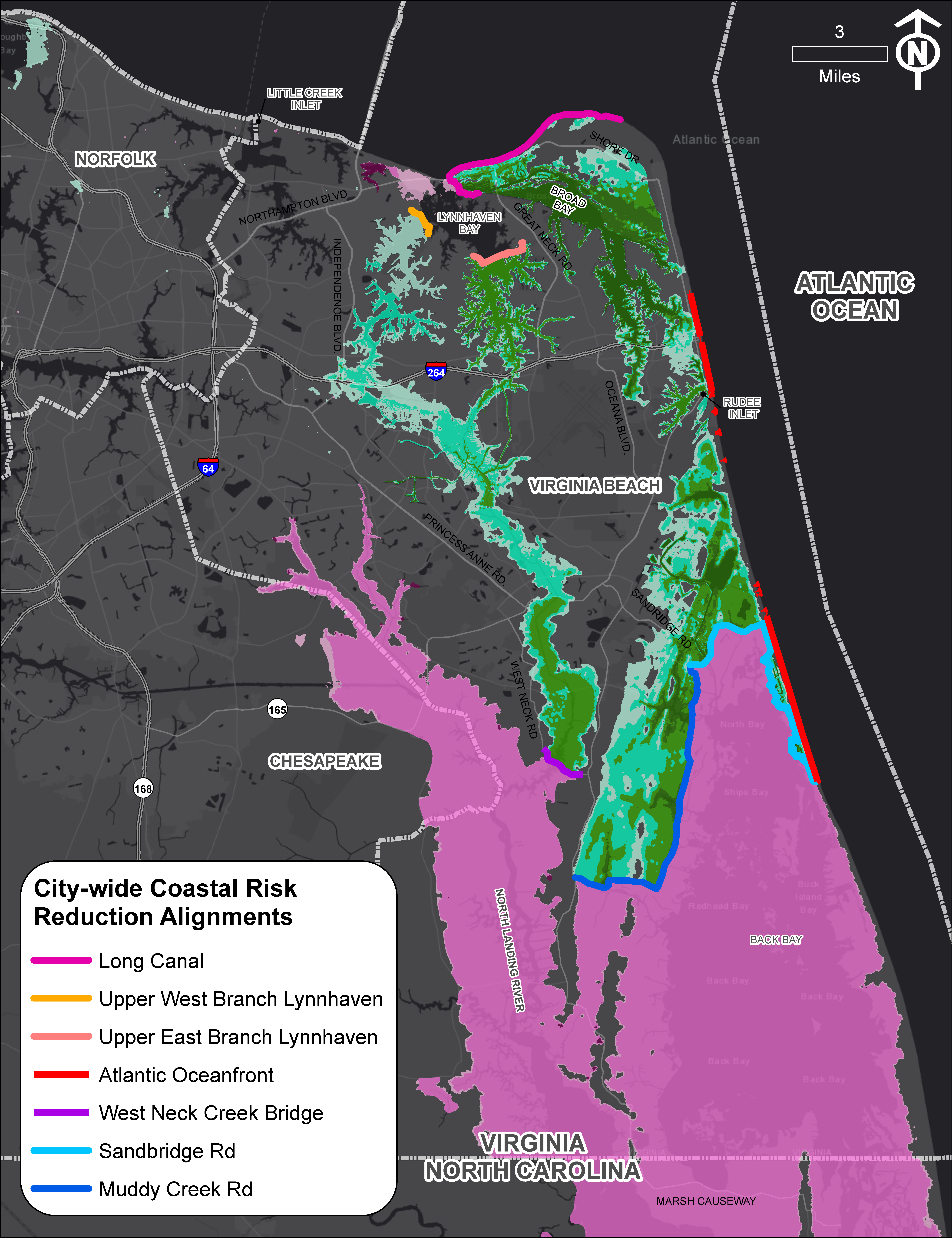
Station 3: City-Wide Structural Solutions
City-wide structural protection strategies are large-scale infrastructure projects that extend across one or more watersheds, substantially reducing coastal flood risks for large inland areas.
![]() Now let’s get more specific. Let’s talk about structural protection strategies, which are large-scale infrastructure projects that extend across one or more watersheds and which substantially reduce coastal flood risks for large inland areas. Look over the various approaches and let us know what your decision would be from the options presented.
Now let’s get more specific. Let’s talk about structural protection strategies, which are large-scale infrastructure projects that extend across one or more watersheds and which substantially reduce coastal flood risks for large inland areas. Look over the various approaches and let us know what your decision would be from the options presented.
Process
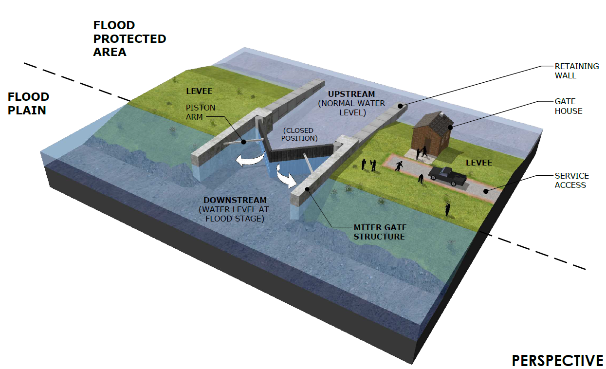
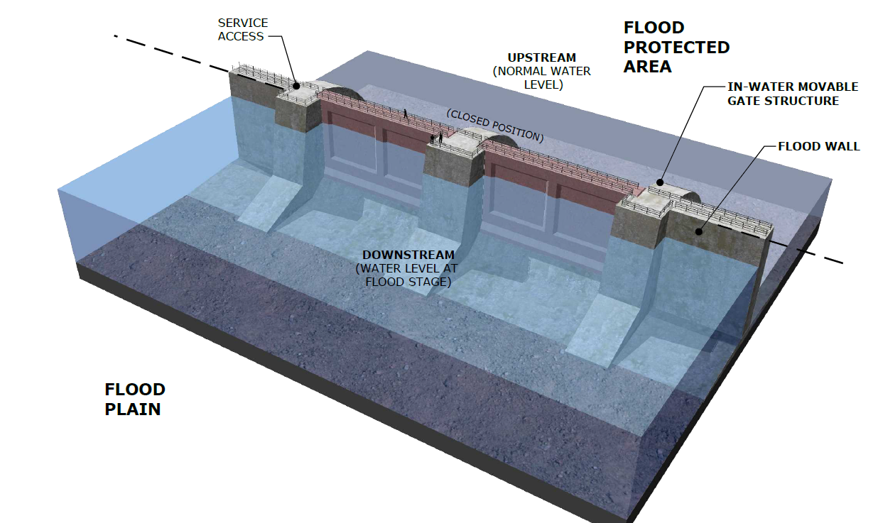
Designing potential city-wide structure flood protection systems was an iterative process, requiring frequent communication with decision makers, stakeholders, and planners. The study team first identified 12 individual structural alignments with 10 different alternatives. Each alternative is a combination of the individual locations to allow for a better understanding of the potential positive and negative impacts at each proposed location.
In coordination with the City and using FEMA, USACE, State and Local Standards and Regulations, the were four steps to the process:
(1) Existing data collection and site assessment
(2) Development of ten citywide alternatives
(3) Hydrodynamic modeling of alternatives
(4) Concept design of top ten preferred alternatives
The hydrodynamic modeling, costs and benefits, and identified site constraints were used to arrive at 3 preferred alternatives, each having 2 options.
Summary of Preferred Alternatives
The figures below show the top three alternatives (A, B, C), from minimum to maximum protection. Each alternative has two alignment options (1, 2) allowing for comparison of costs and benefits across different structural configurations.
Click the images below to view more details of the different configurations (A1, A2, B1, B2, C1, C2). Feel free to rate these alternatives by clicking on the like (thumbs up) or dislike (thumbs down) button.

A1

A2

B1

B2

C1

C2
-

A1
Structure length: 7.8 miles | Flooded area reduced: 21 square miles | Mitigated structures: 28,000 | Design and Construction Cost: $1.13B20 -

A2
Structure length: 12.4 miles | Flooded area reduced: 46 square miles | Mitigated structures: 29,000 | Design and Construction Cost: $2.31B10 -

B1
Structure length: 33.6 miles | Flooded area reduced: 78 square miles | Mitigated structures: 39,000 | Design and Construction Cost: $2.22B12 -
B2
Structure length: 33.3 miles | Flooded area reduced: 74 square miles | Mitigated structures: 37,000 | Design and Construction Cost: $2.77B12 -

C1
Structure length: 34.4 miles | Flooded area reduced: 85 square miles | Mitigated structures: 45,000 | Design and Construction Cost: $2.42B01 -

C2
Structure length: 34.1 miles | Flooded area reduced: 81 square miles | Mitigated structures: 43,000 | Design and Construction Cost: $2.97B20
Risk Reduction Benefits
How much flood risk reduction benefits do the different alternatives provide?
$12 million - Current annualized losses
Annualized losses with 3 ft SLR

Strengths
(1) Large-scale structural intervention concepts provide protection from the future 100-yr flood events.
(2) Alternatives are comparable based on evaluated protection benefits and costs.
(3) Opportunities exist for collaboration with other localities to provide more comprehensive protection.
(4) Designs minimize construction and utilize city-owned/public land as much as practically possible.
Limitations
(1) Concepts are high-level with alignments based on desktop analysis.
(2) Solutions come with significant costs, in the order of billions.
(3) Each alignment will have major impacts and concerns which are not captured in detail.


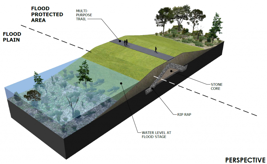

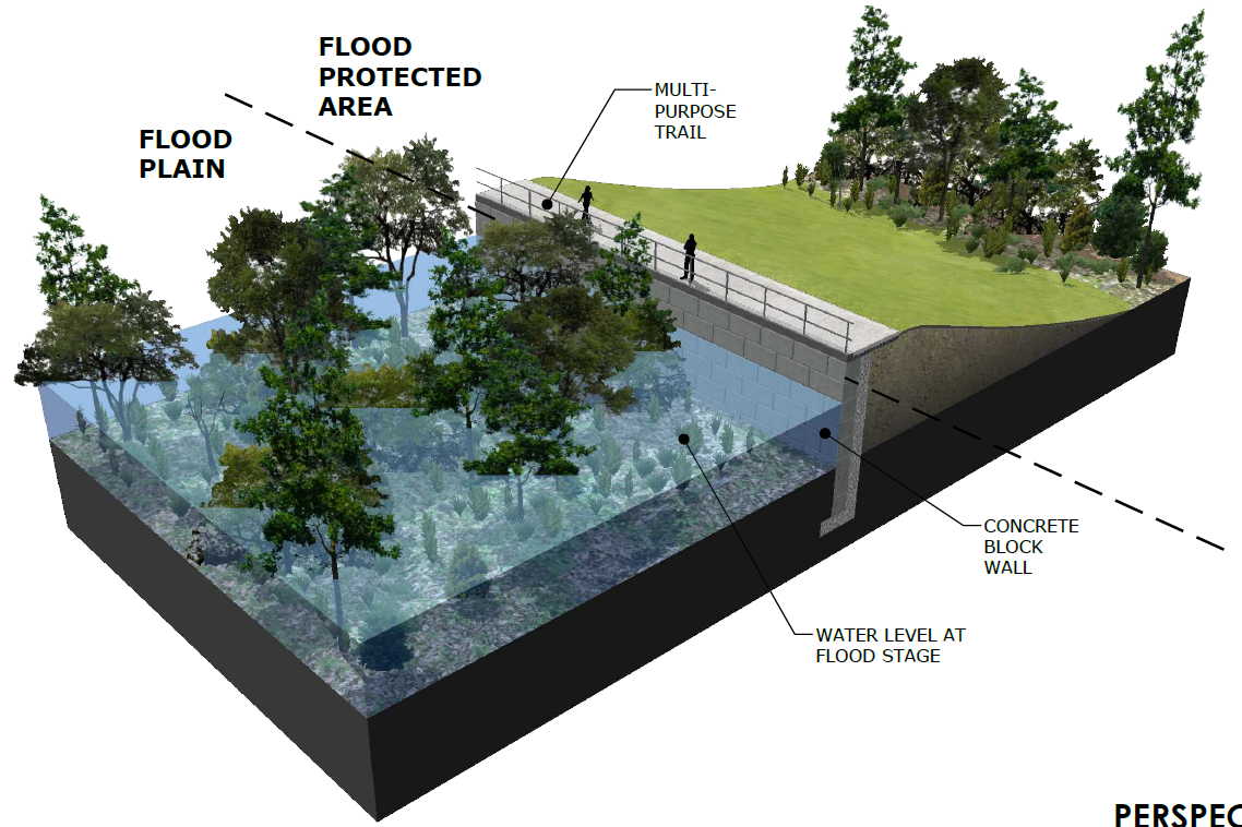


Station 4: Site/Parcel Structural Solutions
Building-level mitigation strategies for residential and non-residential structures can be implemented alone in combination with other measures to provide comprehensive flood protection.
![]() Now let’s get even more specific. This station focuses on building-level mitigation strategies for residential and non-residential structures, which can be implemented alone or in combination with other measures to provide comprehensive flood protection. This station is about learning that individual adjustments can be made by homeowners and/or businesses. Many are safe and cost-effective. How do you change your stance, if at all?
Now let’s get even more specific. This station focuses on building-level mitigation strategies for residential and non-residential structures, which can be implemented alone or in combination with other measures to provide comprehensive flood protection. This station is about learning that individual adjustments can be made by homeowners and/or businesses. Many are safe and cost-effective. How do you change your stance, if at all?
Based on detailed review of benefit cost analysis (BCA) results and other technical data, the following cost effective city-wide and building level flood mitigation strategies were identified for residential and non-residential buildings in the City of Virginia Beach.

Feel free to rate these alternatives by clicking on the like (thumbs up) or dislike (thumbs down) button.

Residential elevation

Residential elevation

Residential demo/rebuild

Residential demo/rebuild

Non-residential dry floodproofing

Non-residential dry floodproofing

Non-residential wet floodproofing

Non-residential wet floodproofing
Property acquisition
-

Residential elevation
41 -

Residential elevation
51 -

Residential demo/rebuild
42 -

Residential demo/rebuild
32 -

Non-residential dry floodproofing
21 -

Non-residential dry floodproofing
21 -

Non-residential wet floodproofing
31 -

Non-residential wet floodproofing
42 -

Property acquisition
61


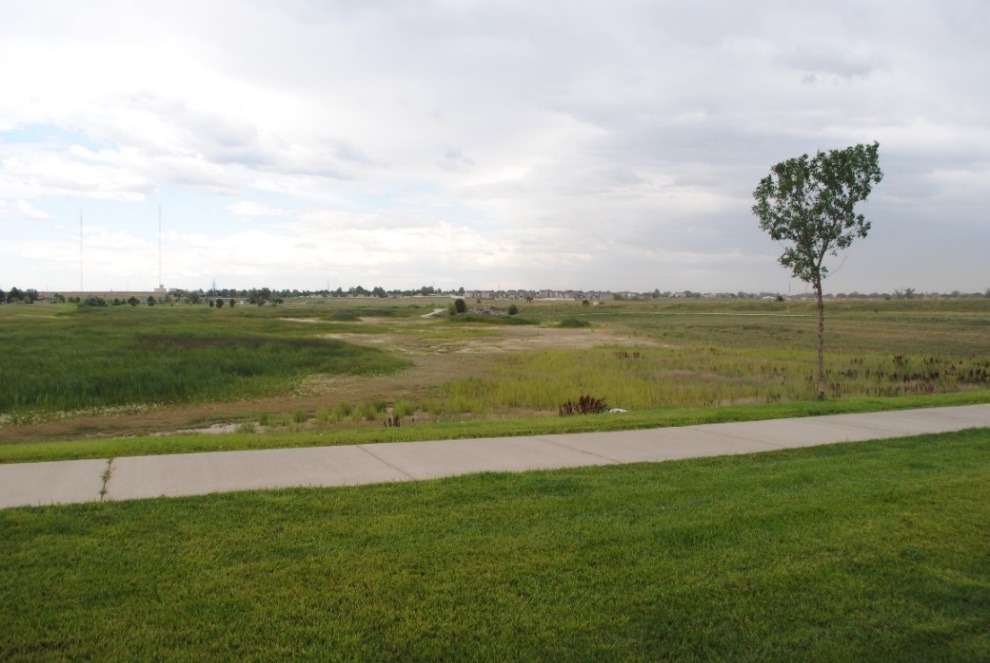
Station 5: Nature-Based Solutions
Natural and Nature-Based Features (NNBF) in the coastal landscape reduce inland flood risks, while also providing economical, environmental, and social benefits to the surrounding area.
![]() Being a decision-maker is tiring, isn’t it? We’re almost done. Imagine now you are tasked with meeting with an environmental group, who provide you with details of nature-based solutions. Natural and Nature-Based Features (NNBF) in the coastal landscape reduce inland flood risks, while also providing economic, environmental, and social benefits to the surrounding area. What would be your approach to these nature-based solutions?
Being a decision-maker is tiring, isn’t it? We’re almost done. Imagine now you are tasked with meeting with an environmental group, who provide you with details of nature-based solutions. Natural and Nature-Based Features (NNBF) in the coastal landscape reduce inland flood risks, while also providing economic, environmental, and social benefits to the surrounding area. What would be your approach to these nature-based solutions?
Multiple Lines of Defense
NNBF are considered a complimentary flood risk management strategy providing redundancy in flood protection, increasing resiliency and enhancing the performance and durability of structural measures.

Case Study for Back Bay
How could marsh island restoration impact flooding?
In Back Bay and northern North Carolina, restoration could:
- Reduce flood depths up to 1.5 feet along Back Bay and Sandbridge shorelines but on average 1-2 inches
- Reduce flood depths greater than 1.5 feet on Knotts Island
- Delay time to maximum flood event up to 4 days

Marsh Response to Sea Level Rise
Marshes play an important flood attenuation role during storm events as they act as a sponge, slowing down the movement of water. As part of the CSLRRF study, the City of Virginia Beach analyzed marsh response to future flooding conditions. Wetland changes were simulated and evaluated to understand what marsh types are most vulnerable or resilient to sea level rise and to identify areas in the city that ae projected to experience marsh loss or gain.

Current conditions

Conditions with 3 ft SLR
-

Current conditions
-

Conditions with 3 ft SLR


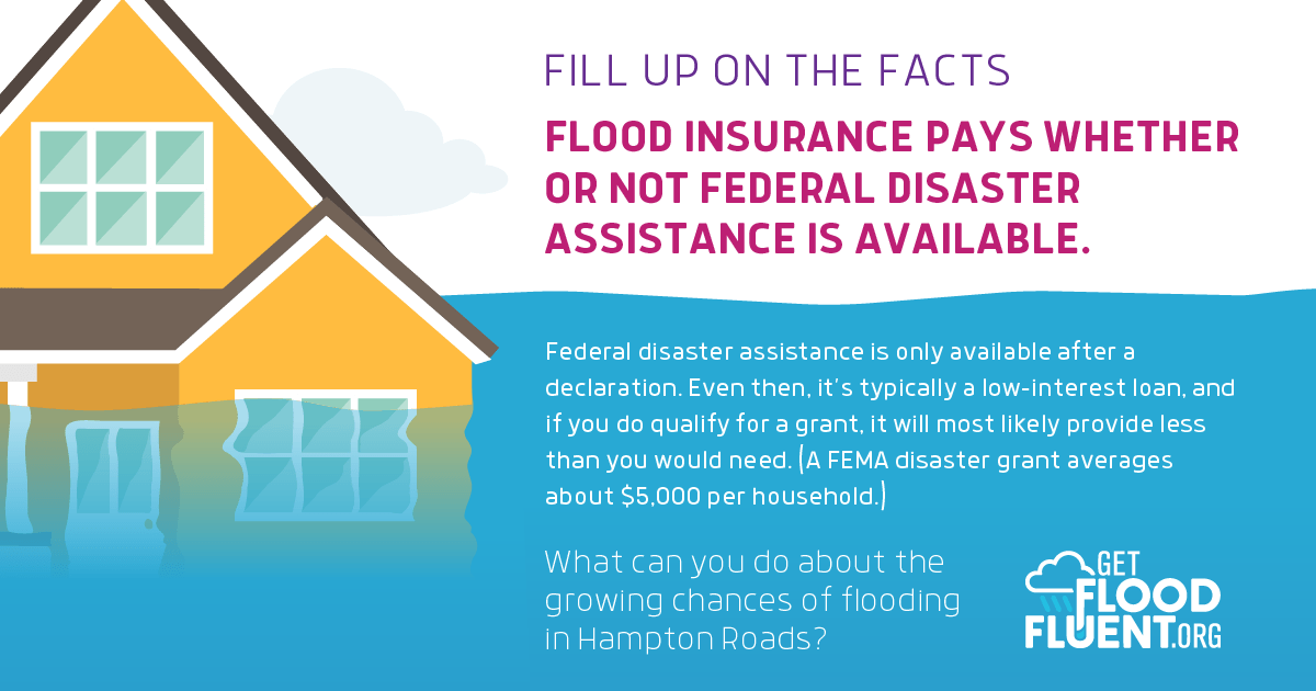
Station 6: CRS and Flood Insurance
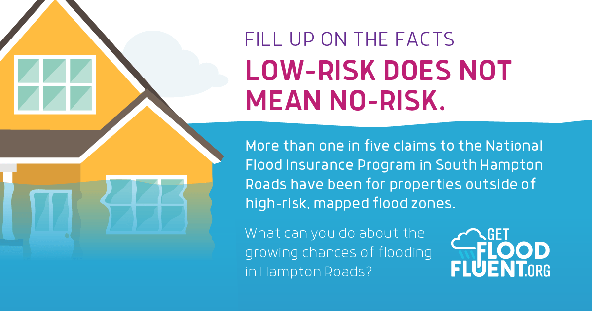
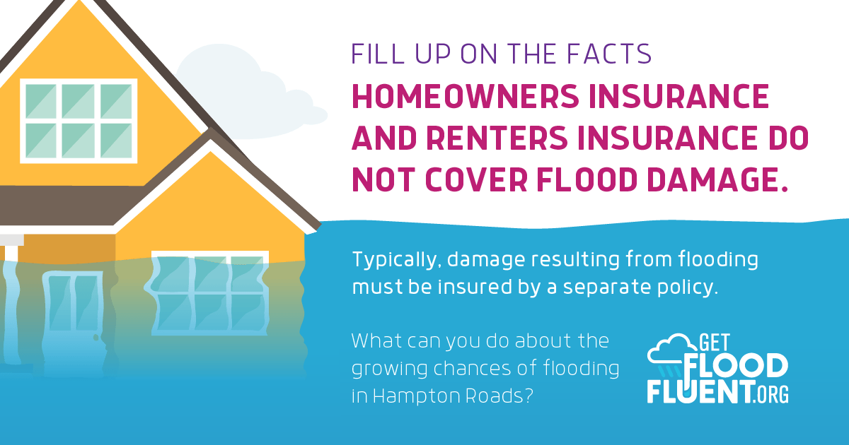
Flood insurance provides coverage against property loss. The Community Rating System (CRS) incentivizes community floodplain management activities through discounting insurance rates.
![]() Finally, let’s end with a hot topic that affects many people in the city: flood insurance. As you know, flood insurance provides coverage against property loss. The Community Rating System (CRS) from the federal government incentivizes community floodplain management activities through discounting insurance rates. The City of Virginia Beach now participates in FEMA’s CRS, and as such has been asked to consider several policy and planning options as part of the city’s comprehensive response to flooding. You also know that flood insurance is an effective tool for reducing flood losses experienced by homeowners. This station is about you assessing why homeowners purchase (or do not purchase) flood insurance.
Finally, let’s end with a hot topic that affects many people in the city: flood insurance. As you know, flood insurance provides coverage against property loss. The Community Rating System (CRS) from the federal government incentivizes community floodplain management activities through discounting insurance rates. The City of Virginia Beach now participates in FEMA’s CRS, and as such has been asked to consider several policy and planning options as part of the city’s comprehensive response to flooding. You also know that flood insurance is an effective tool for reducing flood losses experienced by homeowners. This station is about you assessing why homeowners purchase (or do not purchase) flood insurance.
Why You Need Flood Insurance
Anywhere it rains it can flood. Homeowners, renters and business owners are encouraged to purchase a flood insurance policy. Virginia Beach participates in the Community Rating System (CRS) providing residents in high risk flood zones a 15% discount on their flood insurance policy.
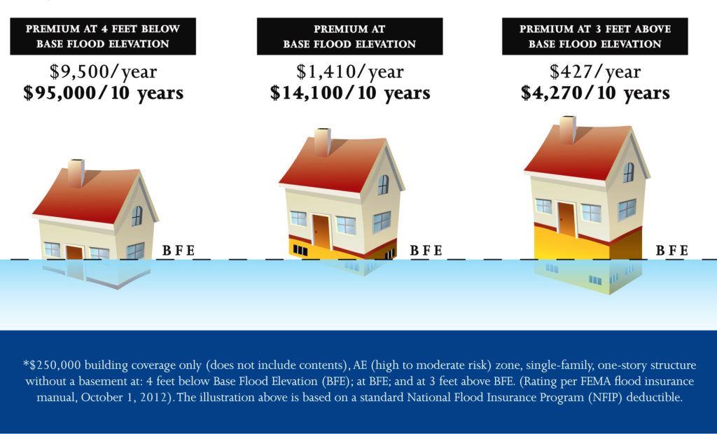

Flood Zones
Residents in high risk zones (A, AE or VE) will receive a 15% discount on their flood insurance premium if they purchase or renew after May 1, 2019.
Residents living in low risk zones (shaded X or X) are eligible for a Preferred Risk Policy. These policies typically cost less than $550 per year.
